It’s been raining heaps in Sydney, but we had a lovely break in the weather on Wednesday which brought brilliant gliding conditions with puffy white cumulus clouds.
I had a dual checkout with instructor Mike Woolley – we launched to 200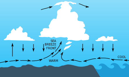 0 feet and, following a group of soaring ibis, we climbed to 3,500 feet in the thermal they were kindly marking for us.
Then I launched in the PZL Junior and found there was plenty of lift. I stayed up for an hour, then landed in case anyone else wanted the aircraft. They didn’t, so I launched again! There was a long line of cumulus stretching north-south near Narellan that was providing plenty of lift. Interestingly, the lift seemed to be all along the front of the cloud line, not so much directly underneath the clouds which is where you usually find thermals.
This, I’m convinced, was a sea-breeze front! The sea breeze is caused by the land heating up more quickly than the sea because is absorbs more sunlight. It warms the air above it, which then goes up because it is less dense (hot air rises, as any fule kno), lowering the air pressure. Cooler, denser air from the sea moves in underneath the warm air and helps push it up.
Wikipedia explains: A sea-breeze front is a weather front created by a sea-breeze, also known as a convergence zone. The cold air from the sea meets the warmer air from the land and creates a boundary like a shallow cold front. When powerful this front creates cumulus clouds, and if the air is humid and unstable, cumulonimbus clouds.
So I wandered around for an hour, climbing to 4,500 feet several times, then the lift gradually faded and I landed. What a lovely way to spend a day.


Was going to say that Narellan is at least 35 km from the sea, but found an article which said “The general distance that SBF extends to the interior is 70-80 km”.